.png)
Top 7 Hikes Along the Lake Superior Coast (easy - moderate) and Why They’re Worth the Stop
- Namratha Prasad

- Jul 21, 2025
- 4 min read
Updated: Nov 28, 2025
+ A Bonus Lookout You Don’t Want to Miss
From rugged cliffs and hidden beaches to ancient pictographs and sweeping canyon views, the Lake Superior coast in Ontario is one of Canada’s most underrated hiking destinations. While I was road-tripping the iconic Lake Superior Circle Tour exploring northern Ontario’s untamed beauty, I had the opportunity to explore some of the best trails with jaw-dropping scenery.
Here’s my take on the 7 must-do hikes (plus one bonus!) ranging from easy to moderate that is perfect for casual hikers, photographers and nature lovers.
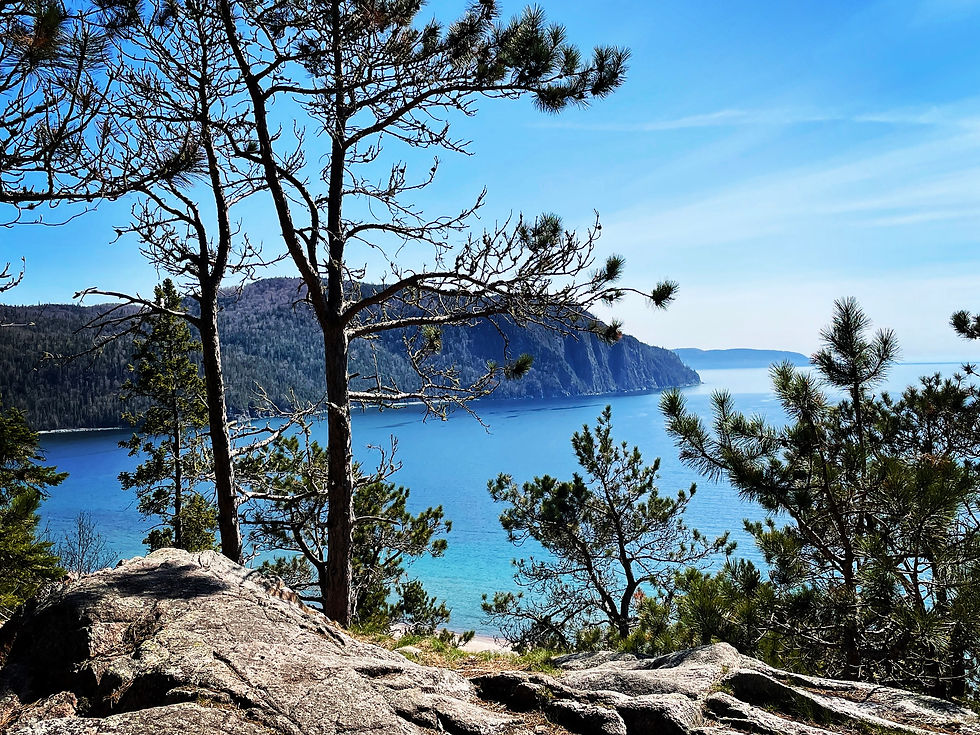
Nokomis Trail – Lake Superior Provincial Park
Distance: 5 km loop
Difficulty: Moderate
Why It’s Worth It: If you only have time for one hike along the coast, make it Nokomis. This short but steep loop climbs high above Old Woman Bay and rewards you with panoramic views of cliffs plunging into the vast expanse of Lake Superior.

There are multiple lookout points and tall trees through boreal forest provide a lot of shade if you have to make stops.
Katherine Cove – Lake Superior Provincial Park

Distance: Varies (~1–2 km casual exploration)
Difficulty: Easy
Why It’s Worth It: Katherine Cove isn't a traditional hike, it's more of a gentle lakeshore ramble. But it’s absolutely worth the stop. The white sand beaches and turquoise water feel almost tropical on a sunny day and offers one of the best sunset views.

This is a perfect spot to stretch your legs, enjoy a picnic, or capture those dreamy Superior beach shots. There’s a short path that connects Katherine Cove to the nearby Bathtub Island, a unique natural rock pool that's become an Instagram favourite.
Agawa Rock Pictographs – Lake Superior Provincial Park

Distance: 0.5 km round-trip
Difficulty: Moderate (due to uneven, slippery rock)
Why It’s Worth It:This short, rugged trail leads to one of the most culturally significant Indigenous sites in Canada. Painted directly onto the cliffs above Lake Superior, the Agawa Rock Pictographs depict centuries-old Ojibwe stories, including the famed spirit canoe of Mishipeshu, the underwater lynx.

Caution: The walk down involves scrambling over smooth rock that can be slippery, so wear good footwear and take caution, especially near the edge. Visit on a calm day.
Sand River Trail (Pinguisibi Trail) – Lake Superior Provincial Park

Distance: 6 km round-trip
Difficulty: Moderate
Why It’s Worth It: Following the Sand River, this trail is a peaceful journey through northern forest, marked by waterfalls, rapids, and smooth bedrock. It’s one of the most tranquil hikes in the area, with plenty of spots to stop and enjoy the sound of rushing water.
Fun Fact: "Pinguisibi" means "fine white sand river" in Ojibwe. The trail follows a traditional canoe route used for centuries.
Gros Cap Bluffs & Connector Trail – Near Sault Ste. Marie

Distance: 5–7 km round-trip (depending on access point)
Difficulty: Moderate
Why It’s Worth It:Located just west of Sault Ste. Marie, this trail offers epic cliffside views over Lake Superior from Gros Cap where the lake’s deep blue waters crash against rugged dolostone bluffs.

The Gros Cap Connector Trail is part of the larger Voyageur Trail, and it's perfect for those wanting a quieter, off-the-beaten-path hike.
Ouimet Canyon Trail – Ouimet Canyon Provincial Park

Distance: 1 km loop
Difficulty: Easy
Why It’s Worth It:This loop delivers maximum reward with minimal effort. Walk along a flat, well-maintained trail to two viewing platforms overlooking the jaw-dropping Ouimet Canyon, a 150-meter-deep gorge carved through billion-year-old rock.
Sea Lion Trail – Sleeping Giant Provincial Park
Distance: 2.5 km round-trip
Difficulty: Easy–Moderate
Why It’s Worth It:This coastal hike takes you to a viewpoint of the iconic Sea Lion, a natural rock arch that was once more complete but still resembles a majestic creature emerging from the lake. The trail follows a beautiful forest path with peek-a-boo views of the water before ending at a rocky lookout over the arch and Lake Superior. If you’re up for a challenge, Sleeping Giant offers longer trails like the Top of the Giant but for something more relaxed, this one is a gem.
Pro tip for photographers: Always carry your backup battery pack and ensure it is charged the previous night.
I forgot to carry my battery pack on this trail and my camera ran out of battery. I missed capturing the stunning scenery this trail offered. But in a way it was a blessing. I soaked in the fresh air and breathtaking views, fully present and distraction-free.
*Bonus: Agustine Gorge Lookout – Near Terrace Bay

Distance: ~1 km round-trip
Difficulty: Easy
Why It’s Worth It: A hidden gem near Terrace Bay, the Agustine Gorge lookout offers a peaceful view of the Agawa River flowing through a dramatic canyon, surrounded by dense forest and rock walls. It’s not a long trail, but it’s a worthy detour if you’re exploring the region.
Final Thoughts
The Lake Superior coast in Ontario is a treasure trove of natural wonders and you don’t need to be an expert hiker to enjoy them. These easy to moderate trails offer some of the best views, cultural experiences, and peaceful moments the North has to offer. Bring layers, bug spray (very essential if you are visiting in late spring and early summer) and a camera. Lake Superior weather can change very quickly and you’ll want to capture every moment.


Comments